Read about the 2nd day of the 3-day hike.
Or read about the 1st day of the 3-day hike.
We woke to the sound of movement from the other campers below us. Some of them had spent the night sleeping in big plastic bags…literally with plastic bags over their heads as well. The night had not been as cold as the night before and I definitely got better sleep in the Takatsuka hut (高塚小屋) rather than the Ishizuka hut (石塚小屋). As with every morning, coffee was prepared before we cleared up and set out. We were the last to leave the building but that didn’t bother us at all.
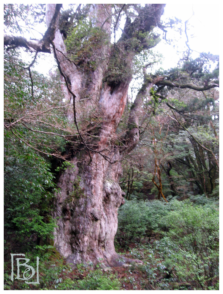
From the Takatsuka hut, the trail was boarded and easy to walk without any ice on the steps. Jōmon Sugi (縄文杉) was barely a 10 minute walk away and was our first stop. It is the oldest and largest Cryptomeria (or Japanese cedar) tree on Yakushima. I was a bit sad to have to look at the tree from afar on a wooden platform; the tree was surrounded by a fence so we couldn’t get closer. Still, the sight was impressive and it was nice to view the tree without a horde of tourists blocking the view.
We continued to follow the Miyanoura trail (宮之浦步道) heading east towards the Okabuhodo mountain trail (大株步道). This part of the trail consisted mostly of steps and in the direction we were heading, it was a constant climb downhill. Along the way, we came across other spectacular highlights like the Meoto-sugi cedars (夫婦杉). This pair of cedar trees are completely different trees but have grown in a remarkable way, where they merge on the middle, resembling a husband and wife holding hands. The larger tree is “the husband” and the age gap between “the husband” and “the wife” is 500 years! Another cedar tree we came by which was standing across from the Meoto-sugi cedars, was Daio sugi (大王杉). It is one of the giant cedars on Yakushima. Standing at 24.7m tall and 11.1m wide, it used to be the largest cedar on the island. Perhaps that is how it got its name Daio, which means “King of Cedars”.

About an hour away from this cluster of cedar trees is the famous Wilson stump (ウィルソン株). The great stump is what remains of a Cryptomeria tree that was cut down about 300 years ago. Still, it receives thousands of visitors everyday as the open roof, viewed from the inside, forms a heart-shaped figure. Perfect for the romantics…I guess. But on this day, we were having a real Yakushima experience as the rain started to pour down in bucket-loads and the number of visitors arriving was increasing exponentially.

We followed the Miyanoura trail which eventually led and connected to the Okabuhodo mountain trail. The Okabuhodo trail was super easy going. It was completely flat leveled ground and we basically walked along a railway track. Despite the downpour, we came by many groups of tourists and in between the groups, we met a number of deer along the tracks. I wonder whether anyone else saw them. We tried to stay still so as not to frighten them away and while that worked and they came close to us, taking pictures of them proved impossible in the rain with such dim lighting.


The rain didn’t stop that day till the evening. So for the rest of the hike, it simply poured down like there was no tomorrow. Along the Okabuhodo trail, we came by the remarkable Sandai Sugi (三代杉) which is a huge Japanese cedar tree that has 3 generations of cedar trees in this one tree. The 1st generation tree fell approximately 1200 years ago. Then the 2nd generation cedar grew over the 1st one and was chopped down when it was a 1000 years old. The 3rd generation cedar then grew over the 2nd generation tree and is now the current tree standing. Not far from the Sandai Sugi came the Kusugawa-wakare (楠川分れ) which is a junction that forks off into the Anbo Mountain trail (安房歩道) or the Kusugawa trail (楠川歩道). As Ghibli studio fans and being keen to visit the region of inspiration for the animation film, Princess Mononoke, we followed the Kusugawa trail that leads to Shiratani Unsuikyo (白谷雲水峡).

The moment we walked off onto the Kusugawa trail, the rain poured heavier and harder than before. The path here was slippery and we were back to climbing uphill. The hubby was practically running during this part of the trail as he had bad rain trousers (non-breathable ones) and had decided against wearing them. However, not only was he entirely wet then but he was cold as well…which was why he was walking so fast, he was practically running while I pretty much took my time to make sure I didn’t slip and fall.
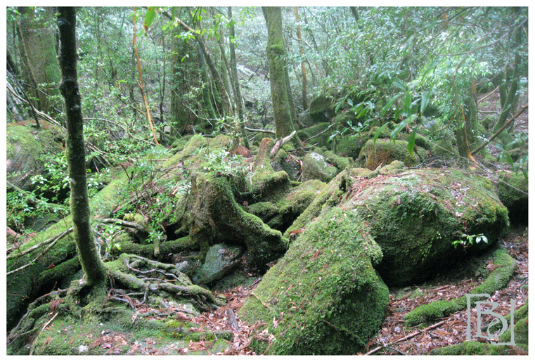
 The Kusugawa trail led us into a beautiful moss covered forest. Every rock and tree was covered with moss. Even without making the short detour and walking through the Mononoke Hime Forest (もののけの森), I could already imagine how the forests in Princess Mononoke was inspired by everything around us. Obviously, we had to walk through the Mononoke Hime Forest and up to the Tsuji Pass (辻峠) to the lookout at the Taikoiwa Rock (太鼓岩). The climb up to the Taikoiwa rock was a sharp climb uphill and took us over an hour to get up and climb down. The walk along the ridge was nice enough and worth the climb already if only it had not rained so much then. We didn’t get much of a view that day unfortunately and many teenagers were hanging around the area so we made our stop here short and climbed back down.

We continued along the Kusugawa trail which was one of the most beautiful forests I have walked through and made a food stop at the Shiratani hut (白谷小屋). This stone and concrete hut was big and spacious with 3 or 4 rooms. I think it even had a toilet because it smelt like a toilet the moment we walked into the hut. Many other visitors had stopped here to take shelter so we were not alone. We stayed here long enough to cook us something warm at the furthest end away from the smell, before braving the rain and cold temperatures outside. From the Shiratani hut, the path was leveled with stone making the walk easier despite the rain.


Our destination was the parking lot and entrance to the Shiratani Unsuikyo ravine/gorge (白谷雲水峡). The stone path eventually gave way to a wooden boardwalk trail and we finally caught sight of the river. We were close to the end! We sat on huge boulders at the river bank for some time watching the fast flowing river as many other tourists walked by. From here, we discovered many other walking trails available for day-hikers along both river banks. But for now, we were done. We walked to the entrance where a bus-stop was located and found that the next bus down to our accommodation was in 5 minutes!! Our amazing 3-day hike had come to an end! We were both sadden and yet relieved it was over! Good Japanese food and some warmth in civilization was welcomed right about now. 🙂

How far on average did you cover each day? I am so impressed. I complain A LOT when I trek and that’s with carrying nothing except my camera.
LikeLike
I reckon on average we were covering something like 15km to 20km per day, which doesn’t sound like much cause it really depends on the elevation and on Yakushima, there was a lot of climbing.
LikeLike
Haha! It sounds like A LOT to me.
LikeLike